
 I've been downstream from Mitchell Bridge, and upstream from Morgan Ford, but had yet to do the entire section at once. Patty was planning on a 4-mile run at Fieldale Trail, and she was taking the puppies with her so she would help me with shuttle logistics.
 Normally, winds are not much of a concern on the Smith as the high banks deflect much of the force; however, on this paddle, a strong March wind would be relentlessly blowing upstream against me for most of the trip. It seemed for every one stroke forward the wind blew me back two. It was going to be a long trip. I began to wonder if I should have put in at Morgan Ford and gone upstream to Mitchell Bridge, I doubt it would have made much difference today. I received permission from a landowner to park at Morgan Ford, loaded the canoe on the Volvo, and the dogs in the back, and we were off to set shuttle at the downstream end. It was 2:30 PM....a little late to get on the river for a long trip, but I like being out past dark, so what the heck.

Finally, we arrived at the put in at Mitchell bridge. I off-loaded the canoe, tossed in my gear and headed to the river. Patty pulled away and I watched as the dogs pressed noses against the back glass wondering why 'mommy' had left 'daddy' on the side of the road, even though they have seen this drill before...it was 3 PM. The wind had really picked up, and as I approached the river I knew it was going to be a long trip. The good news was the water level was about 6 inches above normal so the shallow rapids would not be an issue today.

I really like this "little used" section of river even though it's difficult to access. The neatest thing to me are the beautiful rock outcroppings viewed from the river at a variety of locations. Generally speaking, the downstream river left side is mostly wooded with hardwood ridges, occasional rhododendron patches, and the familiar rock outcrops. River right varies from low bottom land and clear-cuts to some rock outcrops and an occasional hardwood ridge. About 3.2 miles into the trip you approach the area known as "The Bent." This is a very large bend where the river is actually traveling southeast then turns northeast for a couple of miles before heading south again. There are really only class I rapids on this entire section of river; some are more like strong riffles with others having the occasional rocks, but easy enough to navigate without making any real moves. The only decision is where is the deepest part of the rapid to make it through. Just past "The Bent" when you begin heading northeast, you see the large "Whale Rock" on river right. This was the name I got from Bill Trout's Dan River Atlas, and it seemed like a good one to me. 
A nice outcropping with some deep pools and a hardwood ridge with rhododendrons and huge beech trees further up. At this point, you know you are almost halfway.

Just past Whale Rock is a very nice spot to stop and relax for a while. It's a huge bar of rounded river rock with a set of rapids and a nice easy place to get out and stretch. I haven't seen a name for this place so I just called it "Gravel Bar Rapids." This will be the logical spot to stop and take a break on large group trips. Break Reed Ford further downstream would also make a nice place to stop as it has similar gravel bar areas to stop on.

I stayed for quite a while here; it was such a nice place to wade out in the river and make a few casts. I couldn't keep the shiners off my nymph, but they were fun. It was just nice to wade around and enjoy being out here. I knew by the GPS I was only about halfway and probably would not make it out before dark so there was no real rush now.
The Canada geese were keeping ahead of me all the way downstream and would squawk with my impending arrival, fly off and land somewhere out of sight. Belted Kingfishers swooped up and down the river cruising for a meal. Muskrats paddled silently across stream, dipping underwater and out of sight as I edged closer. The rock outcroppings were by far the highlight of the trip and there was even a few small rock shelters to explore.

Here is one of the larger rock shelters along the way. I had to climb up and check this one out from the inside.
 Back on the river again, the sun was dipping close to the ridgeline, and I knew I only had about 30 more minutes of daylight. The moon had already come out so paddling in the dark should not be too bad, but I did start to pick up the pace somewhat.

More beautiful rock outcroppings along the way.

The sun begins to set.
I kept waiting to see a landmark known as "The Big Rock." This was a site Linda Dillard had taken Jenn and I to see 1 year ago. We had hiked a long way down the old wagon road that had run from The Bent to Eden, NC. Mr. Charles Terry had accompanied us on that day and told us all about the area and how the folks would walk from here to Eden to work at Spray Cotton Mill.
The Big Rock was a place for fishing and swimming and some weekends there would be quite a crowd down there. It's not that accessible any longer so the area does not see the kind of visitation it did in the past. Where was it? I knew by the GPS I was not there yet but once I passed it then it would only be another ½ mile to the bridge. I knew it was river right somewhere.
This was not "The Big Rock," but it was still a nice big rock.
 A huge sycamore had fallen nearly across the river, and as I drifted past it I recognized the bend and where I was. Yep, just ahead was the big rock and then the stone pilings, and then Moargan Ford Bridge.
It was "full on dark by now," and I really don't recommend paddling in the dark, but I myself enjoy it. Rapids are defiantly dangerous in the dark, but I knew there were only a few shoals and riffles ahead. I put my headlamp on, but it's really much easier to navigate by moonlight if it's out. The Big Rock hangs out over the water; I drifted silently underneath, turning on my headlamp to get a closer look.
 A lone star shines in the twilight sky as I slide past, or maybe it was Venus? Closer now. Morgan Ford pilings should be next. Will I be able to see them?
This is what the Old Morgan Ford Stone Bridge pilings look like in the daytime.

I could see the pilings silhouetted against the night sky and hear the water lapping around the base as I slid past, but I could barely make out the stone works. I flipped on my light and took a closer look, then drifted on down toward the iron truss shadow of Morgan Ford Bridge. Not much to see this time of night but the moon and the tree line.
Article and photos by: Brian Williams
Edited and posted by: Vicky Thomas


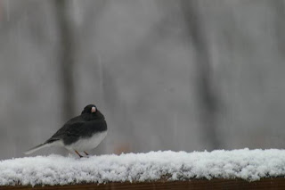 A female hangs out on the deck, picking through spilled seed as a male junco takes a break on the railing and shakes off the snow.
 Tufted titmice, black-capped chickadees and a white breasted nuthatch all had came for the party. Later on, a flash of red signaled a quick stop for a male cardinal. But the snow belonged to the juncos and they spent hours pecking through the piled up flakes to get the millet seed below, stocking up before heading north. Perhaps they'll decide to hang around a few more days...I hope the snow does not.
 It's still coming down out there, even harder now, so I'll make sure to get up early and re-fill the feeders in anticipation of tomorrows lunch crowd.


 The sparkling waters of this tributary cascade down stair-step bedrock ledges as the water falls off the ridge-line and heads for its rendezvous with the Smith.
 Hike along the Smith just about anywhere and you are sure to encounter the ever present gray and white patchy bark of the sycamore as it stretches out over the water, shading the river and making a home for countless insects, birds and other wildlife. Its roots miraculously holding the the bank from spilling into the stream.
 We headed upstream, flanked by tall rock outcrops, the river indifferent to our presence as it continued its run to the coast...
 This old beech tree spreads its roots out over the crumbly, mossy rocks like an octopus spreading out tentacles; the trees full weight seems to crush the stones underneath.


